

Drones for energy and inspection
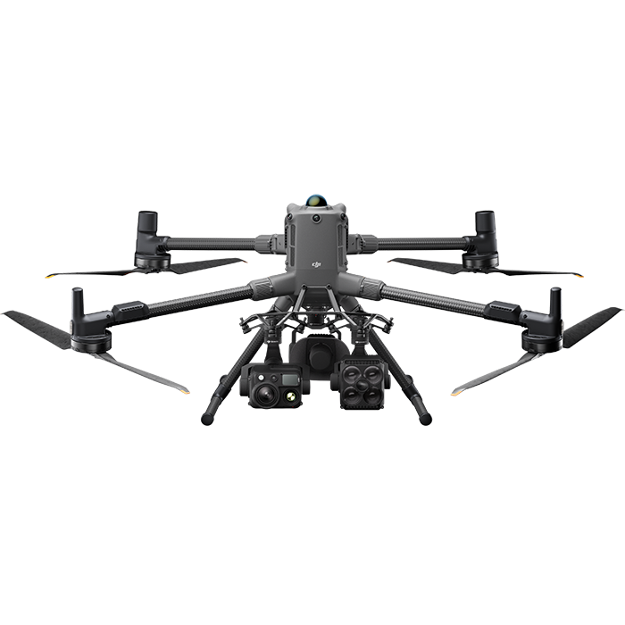
Professional DJI drone systems for substations, overhead lines, wind power, photovoltaics, roofs and bridges – safely planned, properly configured and tailored to real inspection processes in energy infrastructure.
Typical applications for energy + inspection
Extensive facilities, critical infrastructure and recurring inspection cycles place special demands on drone operations. Professional drone inspection creates clear added value in energy and technical infrastructure — what matters is the right combination of flight platform, sensors, thermography and mission workflow.
Safe visual inspection and thermography of switchgear, transformers and substations.
Inspection of overhead lines and pylons with repeatable flight routes and consistent data capture.
Condition monitoring of wind turbines with high-resolution zoom and thermal data.
Inspection of PV systems to detect hotspots, defects and performance losses.
Roof inspections with visual and thermal data for safe, fast assessments.
Bridge inspections for hard-to-reach areas and structured damage documentation.
Automated routine inspections with Dock and cloud workflow for recurring inspection tasks.
Digital models and traceable reports for maintenance, planning and audits.
Automated and manual inspections for critical infrastructure
From one-off ad hoc checks to automated routine inspections: with DJI Enterprise platforms as well as DJI Dock 3 and FlightHub 2, you capture visual and thermal data reproducibly, safely and efficiently – even in demanding environments.
Repeatable missions for consistent data quality at fixed inspection intervals.
Greater safety for teams through distance from high voltage, heights and hard-to-reach areas.
Traceable image, thermal and model data as a reliable basis for maintenance.
Faster decisions thanks to clearly structured workflows from planning to analysis.
Drone-based condition data for safe and efficient infrastructure inspections
Our solutions deliver high-resolution image, thermal and model data for faster decisions in operations and maintenance. From the initial capture to recurring checks, the result is a seamless digital workflow.
Substations and overhead lines
Wind power and photovoltaics
Roofs and bridges
How your inspection workflow takes shape
STEP 1
Define the inspection objective, facility type and safety framework.
STEP 2
Data capture with suitable sensors (zoom, thermal, LiDAR).
STEP 3
Analysis of image and thermal data and, optionally, 3D models.
STEP 4
Integration into maintenance, asset and reporting processes.
STEP 5
Repeatable reports for operations, audit and maintenance.
What makes a professional solution
For energy companies and infrastructure operators, it is not enough simply to select a flight platform. What matters is a solution that fits the mission profile, the organisation, the operating logic and the operational requirements.
The solution must match the actual range of missions — from routine flights to time-critical events.
Size, structure and available resources determine which system can be operated sensibly.
Even under stress and with changing personnel, operation must remain simple and reliable.
Range, endurance and sensors must stand up to real conditions on site.
Why trenderia
When it comes to professional DJI Enterprise drone solutions, more than just the product counts. What matters is experience, an understanding of real operations, reliable support and a partner who truly understands your requirements.
Frequently asked questions about drones in energy + inspection
What data do we receive from drone inspections of energy infrastructure?
Depending on the mission, you receive high-resolution images, thermal data, measurement points and, on request, 2D/3D models for condition assessment, planning and documentation.
How reliable is drone data for recurring inspections?
Clear mission planning and standardised procedures produce reproducible results. The methodology is defined according to facility type and inspection objective.
When are thermography, a zoom camera or LiDAR appropriate?
Thermal is ideal for temperature anomalies and hotspots. LiDAR is suited to precise geometric models of complex structures and corridors.
What do we use DJI FlightHub 2, DJI Terra and Dock workflows for?
FlightHub 2 supports mission planning, fleet control and a central data overview. DJI Terra is used for modelling and structured further processing.
How often should facilities and infrastructure be inspected?
That depends on criticality, regulations and facility condition. In many cases, regular, standardised inspection cycles make sense.
How are results integrated into existing operational processes?
The results are converted into suitable exchange formats and can be integrated into asset management, maintenance and reporting processes.