trenderia DJI Enterprise White WaveDesign logo trenderia DJI Enterprise White WaveDesign logo
Menu
  • Industries
    • Construction
    • authorities and government
    • Energy
    • Agriculture
    • Media and film
    • public safety
    • University and Research
    • Insurance
  • Platform
    • Matrice 4 series
    • Matrice 350 RTK
    • Matrice 30 series
    • Mavic 3 Enterprise Series
    • Mavic 2 Enterprise Series
    • Flycart 30 Delivery Series
    • Agras series
  • Solutions
    • Rent drones instead of buying them
    • Buy a drone for fawn rescue
    • Transport drone
  • Software
    • FLIR Thermal Studio Suite
    • Pixpro – 3D Photogrammetry
    • FlightHub
    • DJI GROUND
  • Sensors
    • DJI
    • DJI Skyport
  • Company
    • Jobs
    • Service & Support
      • Online repair request
      • DJI Maintenance Service
    • Enterprise Drone Blog
    • Brands
    • DJI Drone courses
      • DJI Academy – Flight School – Biel
    • Become a dealer
    • Timeline of DJI Drones
    • Imprint
  • Contact
  • Shop

T: 032 511 11 03

DJI Official Dealer

Author Archives: admin

The best photogrammetry software

Posted in Application, Enterprise Drones, measurement |

March 22, 2023

| by admin | How does

What is the best photogrammetry software?

We hear this question often, and unfortunately, it's not easy to answer. There are different types of photogrammetry software, each designed for different purposes.

This article will help you determine which photogrammetry software is best suited for your needs. There are several different programs available, each with its own advantages and disadvantages.

You will learn the differences between the individual programs and get an overview of their various functions. This will enable you to make the best decision for yourself and optimize your work with the photogrammetry software.

PixPro – the price/performance winner

PixPro is the most advanced photogrammetry software on the market, enabling you to create high-resolution 3D models of buildings, landscapes, and other objects. PixPro utilizes modern algorithms to deliver optimal results.

Further information

Autodesk Recap Pro

Autodesk ReCap Pro is a powerful photogrammetry software designed for creating high-quality 3D models and textures. The software offers a wide range of useful features that enable users to create high-quality 3D models. Autodesk ReCap Pro has an intuitive user interface and a variety of helpful tutorials.

Pix4D

Pix4D is one of the most advanced photogrammetry software programs on the market. Using artificial intelligence and machine learning, Pix4D can automatically create 3D models and maps from photos.

Pix4D is particularly useful for applications in agriculture and forestry, construction, disaster relief and security, and environmental monitoring. The software is also suitable for surveying buildings and other structures.

Pix4D has an intuitive user interface and offers a variety of useful features such as automatic object recognition, the creation of orthographic projections, and integration with ArcGIS.

Manufacturer's website

WebODM

WebODM is an open-source photogrammetry toolkit written entirely in Python 3. It was designed to make creating high-quality 2D and 3D models from digital images as easy as possible. The toolkit includes a number of useful modules required for photogrammetry, such as an image stabilization module, a point cloud module, and a modeling module. WebODM is suitable for both beginners and experienced photogrammetry professionals.

Agisoft Metashape

Agisoft Metashape is a comprehensive photogrammetry software designed for both 2D and 3D applications. The software offers a range of useful features that allow you to create highly accurate 3D models. Although Metashape is a very powerful tool, it is also relatively easy to use, thanks to a large number of video tutorials and online documentation.

Another advantage of Metashape is its compatibility with a wide range of cameras, allowing you to easily process photos from your DSLR, mirrorless, or action camera. Furthermore, it can also process RAW images, meaning you don't need to use converted photos.

Further information

DroneDeploy

Dronedeploy is an app-driven photogrammetry software that allows users to create high-quality 2D and 3D maps. With Dronedeploy, users can create their maps quickly and easily with just a few clicks. The software also offers extensive photography features, including HDR, panorama, and 360° photography. Furthermore, users can also perform vegetation analysis with Dronedeploy.

Manufacturer's website

Conclusion

If you're looking for photogrammetry software, there's a good chance you'll be overwhelmed by the sheer number of programs available. Which program is right for your needs? How much should you spend?

There's no easy answer to these questions, but we can offer some advice. First, consider what kind of photogrammetry you want to do. Are there specific features you absolutely need? Once you have a clear idea of ​​what you want, choosing the right software becomes easier.

Secondly, you should consider how much you want to spend. Photogrammetry software can be expensive, but there are also many affordable options. If you're unsure whether you need a pricey program, you can always download a free trial version first and see if it meets your needs.

Ultimately, it's important to remember that there's no perfect photogrammetry program. Every program has its advantages and disadvantages. The important thing is to find a program that works for you. Take your time to test different programs and then decide which one suits you best.

Drone Guide Switzerland 2023

Posted in Drone regulation |

March 15, 2023

| by admin | How does

Drone Guide Switzerland 2023 – FOCA Drone Rules

Drone pilots must adhere to certain rules to fly their drones legally. This overview summarizes these rules and requirements.

The drone guide provides an overview of the applicable rules (green boxes) and explains when a drone flight requires a permit (yellow boxes). Frequently asked questions and answers are addressed further below.
Drone Guide 2023 - FOCA - Drone Rules - Switzerland

Drone Guide 2023 – FOCA – Drone Rules – Switzerland


Current questions and answers about the new BAZL drone regulations – Drone guide

1. Model aircraft
2. Drone pilot registration / training
3. Liability
4. Geozones
5. Transitional category
6. Special Category
7. Data security and privacy
8. Other


1. Model aircraft

What distinguishes a model aircraft from a drone?
There are three points that can be used as distinguishing features:
On the one hand, the purpose: model aircraft are used for the purpose of sport, leisure, training
or used for demonstration purposes. Secondly, model aircraft are always used in
Flown within visual line of sight. Thirdly, model aircraft have little autonomy.
Skills. The purpose of model flying lies in developing skills and enjoying the experience.
To master a model aircraft. Any autonomous capabilities are used solely for...
Position stabilization and used for emergencies. One cannot simply...
Join a model aircraft club to fly your drone according to the rules for model aircraft.
operate. The same applies to model aircraft pilots who, in addition to model aircraft, also operate drones.
These drones must be flown in accordance with the rules for “drones”.

2. Drone pilot registration / training

If the drone is used by the employee for work purposes, the drone must
then be registered by the employer?
It is not the drone that is registered, but the operators themselves. If the
If the drone being operated weighs more than 250g, in the event of a collision with a person,
kinetic energy of over 80 joules can be transferred, or with a sensor
If the device is equipped with a device capable of collecting personal data (usually a camera), you must...
Pilots must register and complete any required training and
Complete the required tests. If employees act as the drone operator,
They mark the drone with their personal UAS operator number, regardless of whether
They use the drone for work purposes. In case the employer is the owner of the drone...
If a drone is used, they also register as UAS operators, with legal considerations.
Training and examinations are obviously not open to individuals. Accordingly.
These drones will be marked with the employer's UAS operator number.
regardless of the actual pilots who will ultimately operate the drone. If
Liability insurance is necessary for operation (drone >250g), which the employer
As owners of the drones to be operated, the pilots are obligated to comply with the following regulations:
do not have their own insurance for their operation for work purposes (see questions item 3).
However, this does not change the registration requirement for pilots.

Am I allowed to be registered in two countries?
No, duplicate registrations should be avoided.

What happens when the drone's ownership changes?
For example, if you buy a used drone, you must (if you haven't already)
Register as an operator via UAS.gate and make your own UAS operator number visible on the drone, removing the old one from the seller.

Can the choice between legal and natural person be changed retroactively in UAS.gate?
Can be changed?
Yes, please contact rpas@bazl.admin.ch for this.

To what extent is a PPL, CPL or ATPL license recognized for a drone license?
credited?
Not at all, the certificates must be completed in accordance with regulations.

Does the certificate need to be carried in A4 format?
The certificate must be presented, whether in paper form or electronically.
It doesn't matter.

3. Liability

Who (keeper, pilot, owner, etc.) is liable or required to have insurance?
Do you need special insurance or is personal liability insurance sufficient?
Article 35 of the VLK (Federal Law on Aircraft) states that the operator of an unmanned aircraft is liable. The specific circumstances of each case must be considered.
Assess who the owner is. For example, a company can be the owner if the drone
the company owns the drone and the company provides it to the pilots, in
The company has an interest in flying. In such cases, the company will generally be primarily liable.
However, recourse can be taken against the pilots if they act unlawfully.
have traded.
If you are employed by a company and fly company flights but also fly privately,
You also need to have private insurance. Depending on the insurance policy, these damages are covered by
Normal liability insurance covers it, but others require separate insurance for this.
Do I always have to carry proof of liability insurance with me, or is it sufficient to have it shown to me?
What if you're simply properly insured?
Is taking out liability insurance mandatory (drones over 250g)?
Proof must be carried along (Art. 35 para. 3 VLK)

4. Geozones

What is meant by cantonal (municipal) flight restriction zones?
Is there an overview of these areas available somewhere?
The drone map on maps.geo.admin.ch represents the official map, for other maps
The FOCAL assumes no liability. New temporary or seasonal measures will also be introduced.
Area restrictions are displayed, which is why the map must be checked before every flight.
consult. The cantonal area restrictions refer to areas that
which the cantons can determine themselves based on Article 34 of the Ordinance on the Promotion of Local Government (VLK). The cantons were
requested to provide this cantonal data to the BAZL so that all areas are included on the drone map
This will become apparent. This also includes any municipal areas where a corresponding
A legal basis exists. Drone operators should be able to...
You only need to consult a map to see all restrictions at a glance.
What about hospital helipads? Are these considered airfields?
Hospital helipads are not airfields, but areas where regular use by other means of transport takes place.
Air traffic must be taken into account. In the vicinity of helicopter landing pads at hospitals and
Hospitals therefore require special attention and caution when operating drones.
What are the regulations regarding flying over highways and other roads?
and, for example, high-voltage power lines?
There is no rule as such that prohibits the operation of a drone over a highway or road.
or, for example, prohibits a power line. The EASA rules for the
Regulations concerning the operation of drones over moving vehicles have been published. The following points should be noted.
account.
For roads: To reduce potential risks to third parties, the pilot should avoid flying over them.
Avoid driving on busy roads unless there is an operational need.
Motorcycles, bicycles or other vehicles where the persons are not protected,
should be considered uninvolved persons.
For highways: Hovering and continuous flights over or along highways pose a challenge.
They pose the greatest risk to uninvolved persons and should therefore always be avoided. Furthermore
Crossing motorways in subcategory A3 should always be avoided.
Finally, in all cases: Please minimize the risk as much as possible.
distraction of drivers.

5. Transitional category

How should the transition period be interpreted? Is it still permissible to use old methods during this period?
Rules fly?
The transitional period lasts until the end of August 2023 and is not linked to the transitional category.
(See website, open category.) The transition period applies to those
Operators who require a new permit. The transitional period provides
Operators have until the end of August to obtain such a permit.
Therefore, according to the existing rules (VLK), flying in 2023 is permitted without authorization.
Flying over crowds and flights in BVLOS were already permitted.
They require approval, and will remain so. The transition period therefore offers no advantage.
Free pass. Further information (BBl 2023 96 – Exceptions to the provisions on the
Operation of unmanned aerial vehicles (admin.ch). The transitional period applies only in the
Switzerland and is based on Art. 43 para. 2 VLK.

6. Special Category

How long does it take to obtain a SORA permit?
Please calculate at least 3 months one, depending on the quality of the documents and the number
However, it can also take longer to process requests.

How quickly can SORA changes be adapted and approved by the FOCA?
It depends. If the change affects the safety assumptions made, a new SORA may need to be submitted. However, if the change...
Since it has no impact on the safety assumptions, such an adjustment can be made in approximately one
will be processed this week.

What needs to be considered during survey flights?
Unfortunately, no general statement can be made about this. It depends, for example, on...
which area, with what type of drone and under which conditions (BVLOS, VLOS)
is flown. Like all drone operators, you should consult the drone guide on the website of the
BAZL will review the regulations. If the rules of the Open Category cannot be followed,
The business falls into a special category and therefore requires a permit from the
BAZL is required. If operation in the Open Category is possible, then of course the following must be observed.
The required training courses and exams will be completed.
Finally, in this regard we would like to refer to the VDGS (Association for Drone Operations).
Geomatics Switzerland (vdgs.ch)), which has received approval from the BAZL.

What options do filmmakers have? Will there be a STS for filmmakers?
Give it a try? The Swiss Association of Professional Photographers and Filmmakers (SBF) has established a task force.
This body, together with the BAZL, examines whether and how the SBF specifically manages its members in the
The association can support the approval process. It communicates this on its website.
Website. Interested parties can contact the task force leader, Mattias Nutt, directly.

Is it possible to obtain permits that are independent of location?
Generally yes, but it always depends on the specific case.

I need help with a SORA. Who can I contact?
There are consulting firms that offer services in this area. The FOCA (Federal Office of Civil Aviation) has no [information/context needed].
This list of companies does not provide specific recommendations. Please inquire, for example, with...
over the Internet.

Will the BAZL offer courses in the future that specifically deal with SORA or
Should we deal with PDRA?

The Swiss Federal Office of Civil Aviation (BAZL) will not be offering any courses for PDRA and SORA. However, a webinar is planned.
to organize for the “special” category.

7. Data security and privacy

Can a landowner (farmer) prohibit me from flying over his land?
Property owners may be liable for damages due to the noise caused by drone flights.
or even physical danger, and above all, a violation of your privacy.
There are various ways to combat such disturbances.
For example, in order to prevent overflights, a court order is required (Art.
258-260 of the Code of Civil Procedure) or a provisional measure (Articles 261-269 of the Code of Civil Procedure) is also possible, whereby
The latter is provisional in nature and linked to ongoing civil proceedings.
a longer-term solution, and especially because it is aimed at an undefined group of people.
Since the objective is to achieve a specific goal, a court-ordered injunction is more suitable. However, only those who are subject to an injunction can act as "recipients."
Those with real rights to the property (especially owners and usufructuaries) are eligible; tenants are not included.
e.g., out of consideration.
In addition to prohibitions, the fundamental right of owners to “freedom from disturbance” can be enforced.
resp. owners also through civil law actions, such as the action for protection of property rights (Art. 641
para. 2 of the Swiss Civil Code), the action based on neighbor law (Art. 679 et seq. of the Swiss Civil Code) or the action for disturbance of possession (Art.
928 f. ZGB) are enforced.

At what altitude are flights permitted over private property?

There is no general answer, as each case is examined individually to determine the extent of the interest.
a property owner's structure protrudes into the airspace. If a violation is alleged, this is due to
to be judged by a civil court. However, there are opinions in legal scholarship which, in the case of an overflight,
At a height of 20m, already a violation of privacy is acknowledged.

8. Other

What are the consequences of non-compliance with the new regulations?
The Federal Office of Civil Aviation (BAZL) is usually responsible for prosecuting any criminal activity. Depending on the crime,
but the cantonal public prosecutor or, for more serious offenses, the federal prosecutor's office
The Federal Office of Civil Aviation (BAZL) is responsible. It does not maintain a catalog of fines; penalties are determined on an individual basis.
established.

Where can I find the rules for operating unmanned aerial vehicles from other countries?
The new rules apply within the EU and Switzerland. Some provisions will be applied to
regulated at the national level and can also differ within the EU (e.g.
Area restrictions, minimum age for pilots, or model aircraft flying). Countries
Countries outside the EU usually have different rules, so you should contact the relevant countries for more information.
You will have to find out for yourself.

My drone has no class marking. Is a subsequent classification (so-called...) possible?
Retrofit possible?
Yes, however, it is up to the manufacturer to decide whether and which drones he
who wishes to reclassify. With the class marking, the manufacturer guarantees that the
The drone meets the technical requirements of its respective class. The manufacturer can [provide further information].
perform a conformity check on an older drone model and the drone
Classify retroactively. The operator usually also needs to update the drone's software.
Update. Once this is done, you will receive a label from the manufacturer, which you should attach to the
to attach a drone. For further information on the retrospective classification of a
For drone-related issues, please contact the manufacturer directly. Without a class marking, the drone cannot be used.
The drone may continue to be used according to the rules of the transitional category (see section 5).

Are there rules for indoor flights?
Enclosed spaces are not considered airspace, therefore no exceptions apply in this area.
The new rules for unmanned aerial vehicles do not apply.

What is meant by a crowd of people?
“Crowds” [are] a large number of people standing so close together,
that it is virtually impossible for a single person to remove themselves from this crowd."
(Article 2, point 3 of Implementing Regulation (EU) 2019/947).

If your question has not been answered, please contact our team.

Source: FOCA Switzerland

You are interested in a DJI Enterprise Drone? Visit our showroom and let our drone experts advise you personally. Contact Enterprise.

You are interested in a DJI Consumer drone? Click here to go directly to our online shop with all the latest models. DJI Drones, as well as extensive accessory ranges. DJI Drone shop.


bazldrone lawdrone guidedrone regulationeasasetuas

trenderia is the main sponsor of the Bern fawn rescue at the Bern Monthura

Posted in fawn rescue, Uncategorized |

February 24, 2023

| by admin | How does

Discover the latest thermal imaging drone systems for fawn rescue at the MONATURA Bern premiere from March 23rd to 26th, 2023 at the stand of the Bern Fawn Rescue.

The Bern fawn rescue team will provide you with comprehensive advice. We look forward to your visit.

Monatura – The Swiss Nature and Adventure Fair. The Swiss nature and adventure fair combines the four thematic worlds of mountains, fields, forests, and water, thus addressing topics such as nature in general, biodiversity, sustainability, and slow outdoor activities like hiking or canoeing. With topic-specific presentations, exciting workshops, and the latest products and trends from exhibitors, MONATURA is an interactive experience platform for young and old. Whether you're a nature and outdoor enthusiast, angler, hunter, or conservationist – ambitious trade visitors are just as welcome as curious school classes and families.

Drones on display at the Bern fawn rescue stand:

  • Mavic 2 Enterprise Advanced with thermal imaging live stream
  • Matrice 30T

More info:

www.monatura.ch

www.rehkitzrettung-bern.ch

Fawn Rescue Shop

current dronesfairMonaturafawn rescuefawn rescue

DJI RC Controller – Drone Compatibility 2023

Posted in Uncategorized, Infographics Drones |

January 18, 2023

| by admin | How does

Compatibility list of DJI RC Controller

Innovation comes at a price, as demonstrated by the wide variety of "smart controllers" available. DJI which has already been produced, we are talking here about remote controls / RC controllers with integrated display.

To shed light on the matter, we have created a handy infographic with current information. DJI remote controls and the corresponding drones were created.

As you can see from the graphic, many RC controllers are only compatible with one model, but there are differences and exceptions. For example, the DJI Smart Controller, the only controller that is suitable for a Enterprise and consumer drone can be used, or the new ones DJI RC and DJI RC PRO controllers, which can be used across the entire current consumer drone range, i.e., for DJI mini 3 pro, DJI AIR 2S  and Mavic 3 series (Consumer). Certain DJI RC controllers can be used with different drones – Which ones? DJI Drone with which DJI You can find detailed information about RC controller compatibility in the infographic. DJI Check controller compatibility.

Compatibility DJI RC Controller

PDF download file in print quality: DJI-CONTROLLER-COMPATIBILITY-TRENDERIA-2023-XS

Questions, incorrect or missing information

This article was written using the latest information and knowledge. Do you have any questions about the article, or have you encountered any incorrect or missing information?

We would appreciate your feedback; you can reach us as follows:

Contact


dji rcdjircplusdjircprodjircproenterprisedjismartcontroller

Happy Holidays – Opening Hours over the 2022/2023 Holiday Season

Posted in Uncategorized |

December 16, 2022

| by admin | How does

Dear customers, partners and friends

An eventful year 2022 is drawing to a close and we hope you have a wonderful Christmas!

We at trenderia look back on the hard work and dedication you have shown, and we would like to thank you!

It has been a wonderful time working with you this year, and we hope you will follow our journey into the future with great interest.

Our offices, as well as our consulting and sales departments, will be closed from December 24, 2022 to January 8, 2023. However, our support team will be available via email during this time.

Warmest regards, your trenderia gmbh


trenderia gmbh - DJI Enterprise Become

trenderia gmbh – DJI Enterprise Become

New drone regulations 2023 Switzerland

Posted in Drone regulation, Uncategorized |

November 30, 2022

| by admin | 2 Comments

It is now official: Switzerland will adopt the European drone regulations as of January 1, 2023.

In this article, we want to answer your most pressing questions and link to relevant websites to find more information about the new legislation.


Am I still allowed to fly my old drones?

Generally, drones without a class marking can still be operated. There will be a special transitional category for these, which will become progressively more restrictive. See below under the question "What rules apply to all drones without a class marking?".


Do I need an ID/test/registration?

Yes, from January 1, 2023, every pilot may be subject to a registration and examination requirement.

Registration obligation:

  • Drones weighing >250g
  • Drones weighing less than 250g, equipped with a camera

Compulsory examination:

  • Drones >250g, depending on the category, proof of competence (A1/A3) or remote pilot certificate (A2)

The most important changes for operations in the open category:

  • Registration required via UAS.gate
  • Training with exam according to subcategory (A1, A2, A3).
  • The minimum age for drone pilots is 12 years.
  • Minimum distance to uninvolved persons according to subcategory.
  • Maximum flight altitude of 120m above ground
  • Drones must be marked with a CE marking and a class marking. Transitional provisions apply to drones without a class marking.

Depending on the category, proof of competence or a remote pilot certificate will be required.

Exceptions apply to model aircraft . See question below: “Exception: SMV – Code of Good Practice”.

Most commercial applications, such as inspection flights, survey flights, etc., are covered in the " special category ." New standard permit procedures according to EU-STS, CH-STS, or PDRA are available for this area. Please feel free to contact us if you have any questions about these procedures.


Do I need a permit for every flight?

No, this depends on the drone used and the planned flight area. All flights in the open category can be carried out without additional authorization. The following regulations apply to the open category:

Drone regulations

Drone regulations

All other flights require approval from the FOCA (Federal Office of Civil Aviation).


Exception: SMV – “Code of Good Practice”

Thanks to strong lobbying efforts, the Swiss Model Aircraft Association (SMV) negotiated extensive privileges for model aircraft flying. These privileges are available to both SMV members and non-members. Non-members can carry a signed copy of the SMV's "Code of Good Practice" and are therefore exempt from the new EU regulations. There is also no registration requirement for model aircraft flying. Thus, the legal regulations for model aircraft flying in Switzerland remain virtually unchanged.
Perhaps the most important change for model aircraft pilots residing in Switzerland is that from 01.01.2023 onwards, they can register with the BAZL (instead of previously in the EU) if they wish to fly in the EU.

Official information from the FOCA regarding the special exemption SMV


Which drones have the new C-class marking?

Currently, there are only a few certified drones on the market:

  • DJI Mavic 3 series

(List not exhaustive)


Will my already purchased drone be retrofitted with a class marking?

DJI Some products are being considered as a potential option for retrofitting a class marking, which would require a firmware update and possibly the replacement of accessories such as propellers. Currently, it is not yet certain that any model will be eligible for retrofitting a class marking.


What rules apply to all drones without a class marking?

For drones without a class marking, the following special regulation applies:


New drone map from the FOCA

As part of the adoption of the EU drone regulations, the Federal Office of Civil Aviation (BAZL) will revise the official drone map and incorporate all cantonal regulations and no-fly zones in the coming weeks or months. This will ensure that all applicable restrictions are available on the map. The completion date for implementing the cantonal guidelines has not yet been announced.

Drone map of Switzerland


My drone is already registered abroad – is that sufficient?

In principle, registration in any European country is permitted. However, this only applies as long as the drone is intended for use in the open category . It should be noted that the Swiss Federal Office of Civil Aviation (BAZL) is no longer the responsible authority, but rather the authority in the country where the registration was carried out.

However, if flights requiring a permit are carried out (special category), the drone registration must correspond to the owner's place of residence. Therefore, such pilots/operators are obligated to have their registration in the third country deleted and to register again in Switzerland. This transfer takes place in two steps:

  1. Registration via the Swiss portal UAS.gate
  2. Deleting the registration abroad. Either via the foreign portal or by email to the civil aviation authority of the country of registration.


Questions, incorrect or missing information

This article was written using the latest information and knowledge. Do you have any questions about the article, or have you encountered any incorrect or missing information?

We would appreciate your feedback; you can reach us as follows:

Contact


Related Links

  • New drone regulations – open category (BAZL)
  • Official FAQ (BAZL)
  • Training and registration platform (BAZL)
  • Drone map (BAZL/admin.ch)
  • Code of Good Practice (SMV)


Top 5 features of the DJI Mavic 3 Enterprise Series (M3E and M3T)

Posted in Enterprise Drones, Uncategorized |

November 17, 2022

| by admin | How does

The Mavic The 3E (M3E) is a compact, portable, and powerful drone for everyday use. Whether you're preparing to become a professional pilot or looking for a versatile platform to expand your fleet, the 3E (M3E) is ideal. Mavic 3E is setting new standards in the industry. Mavic The M3E is the easiest surveying drone to use to date. With the DJI Mavic 3 Thermal ( DJI In addition to the M3T, a thermal drone is also available for rescue and follow-up operations and inspections. The M3E replaces, among other things, the Phantom 4 RTK drone previously developed for surveying.

DJI Mavic 3E vs DJI Phantom 4 RTK

In short, we have at the Mavic The 3E offers roughly twice the battery life and roughly twice the area we can survey in a single flight compared to the Phantom 4 RTK.

Here are the top 5 features of the new Mavic 3 series

Camera for fast, precision measurements

At M3E, we specialize in reducing the time required to conduct aerial photography without compromising data depth or the quality of the results. Mavic The 3E offers exactly that, with a 20-megapixel 4/3 CMOS wide-angle sensor and a mechanical shutter that reduces motion blur during surveillance flights. The new camera also enables fast 0,7-second interval shooting, allowing you to complete mapping assignments in a fraction of the time compared to previous models.

We also faced the challenges of low-light conditions. The wide-angle camera of the Mavic The 3E features 3,3μm pixels and improved software that takes low-light performance to a new level, significantly expanding your potential operating window. Operations at any time of day or night are now truly possible, and even on cloudy days, measurements can be taken without any loss of image quality.

Last but not least is the Mavic The 3E is equipped with a 12MP zoom camera that supports up to 56x maximum hybrid zoom. Pilots can see important details from a distance with a smooth, continuous zoom instead of stepped zoom levels.

By combining an RTK module with a mechanical shutter, short shooting intervals of 0,7 seconds, and improved low-light performance, we expect the M3E to become a reliable drone platform for rapid aerial surveying.

Foldable and lightweight

The M3E is based on the Mavic 3-Drone PlatformThe M3E, which launched to great acclaim at the end of 2021, redefined industry expectations for relatively small drones. It builds upon these core capabilities, combining its foldable and lightweight design with a host of powerful features.

The M3E can be carried in one hand and deployed in an instant. This makes it a perfect device for beginners and a versatile tool for established drone projects. As always, we've focused on portability without sacrificing performance. The M3E has a flight time of 45 minutes, allowing you to cover a large area on every mission. It can survey up to 2 square kilometers in a single flight.

Powerful security and connectivity features

The M3E is a robust drone platform that prioritizes safety and performance, even in challenging missions. Its advanced obstacle detection and navigation systems provide commercial pilots with the necessary guidance and safeguards to reduce the risk of accidents.

The latest generation of the DJI The Advanced Pilot Assistance System (APAS) combines data from six image sensors and two wide-angle sensors to detect obstacles in all directions and automatically plan your flight paths in avoidance mode. You can adjust the distances between these triggers and the aircraft's braking distance to suit your mission requirements. APAS also supports the M3E's advanced Return to Home function, which plans and executes the most efficient and trouble-free return flight possible.

The M3E offers pilots an early warning of manned aircraft transmitting ADS-B signals through its integrated AirSense system.

As far as connectivity is concerned, the M3E features the latest DJI-Image transmission technology. The O3-EnterpriseFour-antenna transmission enables a more stable connection between pilot and aircraft in complex environments.

Optimized for flight and mission efficiency

For professional drone pilots, time is money. In emergencies, even a few minutes can mean the difference between life and death. For this reason, the Mavic-3-Enterprise-Series developed taking operational efficiency into account.

In addition to the impressive flight time of 45 minutes, we have minimized mission interruptions through a 100-watt fast charging function and a 100-watt charging station with three batteries, so that pilots have enough batteries to stay in the air almost 24/7 if needed.

Thanks to the 0,7-second intervals, aerial surveys can be carried out in a fraction of the usual time.

These features make the M3E an ideal drone platform for rapid deployments and surveys under time pressure.

High-performance accessories for professional pilots

The M3E is available with a range of accessories that make the work of professional pilots and corporate customers easier. The M3E is equipped with the new DJI-RC-Pro-Enterprise compatible, a powerful remote control with excellent screen display in direct sunlight and a built-in microphone as well as a text-to-speech function for direct communication between pilots and people near the drone.

A new speaker offers greater volume with lower battery consumption than previous models; pilots can record messages directly via the remote control or use the integrated text-to-voice function.

A new, weight-reduced RTK module, in combination with the D-RTK 2 Mobile Station, enables precision measurements with centimeter-level accuracy.

The previous for the Mavic-2-EnterpriseThe M3E's available position light accessories are now fully integrated into the M3E, eliminating the need to rely on an accessory slot to comply with local regulations when operating at night or in low-light conditions.

Two models, numerous applications

The Mavic-3-Enterprise-Series It is available in two models: M3E and M3T.

The M3T features the same 12MP 56x hybrid zoom camera as the M3E, alongside a 48MP wide-angle camera and DJI's flagship 640 × 512 temperature sensor.

The M3E supports point and area temperature measurements, high temperature warnings, color palettes and isotherms – all these features help you identify targets and make the right decisions during night flights, firefighting operations and search and rescue missions.

A comprehensive software package and powerful developer tools

The M3E is equipped with the powerful software of our Enterprise-ecosystem connected to support the full range of flight functions, payload management, mission planning and fleet analysis. DJI Pilot 2 and DJI Flighthub 2 simplifies flight management and makes every mission intuitive and collaborative. DJI Terra unlocks the full mapping capability of its already impressive aerial surveying solution. DJIThe Thermal Analysis Tool 3.0 enables the potential of the M3T to support intelligent inspections.

We are also committed to making the M3E available to developers. If you want to build on the M3E, the Payload SDK and Mobile SDK simplify the process of integrating third-party payloads and extending the functionality. DJI Pilot 2. If you want to develop your own solution, it allows DJI's Cloud API allows developers to connect the M3E's hardware, video feed, and photo data with third-party software.

We are excited to see how our developers will expand the functionality of the M3E.

If you're interested in what you're looking for Mavic 3 series Platform?
Write us a E-mail or book a demo appointment with us in Port at our showroom.

DJI Mavic 3 Enterprise Price: (Current daily prices directly in the online shop)

  • DJI Mavic 3E (M3E)
  • DJI Mavic 3 Enterprise Thermal (M3T)
m3em3tmavic 3mavic3enterprisethermalthermal dronesurveying dronethermal imaging drone

Matrice 300 RTK – Firmware mismatch for TB60 battery and BS60 battery station

Posted in Uncategorized |

July 6, 2022

| by admin | How does

DJI On May 21, 2022, a new firmware update was released for the TB60 battery (v01.02.05.44) and the BS60 battery station (v04.00.01.03). This firmware optimizes the charging strategy and improves battery life. However, if the TB60 battery with this firmware (v01.02.05.44) is used with the BS60 battery station running v03.00.01.01 or an earlier firmware version, an alarm may be triggered and the LED indicator light on the battery station may remain solid red.
This problem is caused by incorrect charging strategies and can be fixed by updating the battery station to the latest firmware.

Update.
(TB60: v01.02.05.44, BS60: v04.00.01.03)

The update method is as follows:

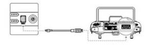
1. Insert the batteries into the battery terminals and turn on the Battery Station.
2. Connect the Battery Station to the remote control using a USB-C cable.*
3. Turn on the remote control and make sure it is connected to the internet.
4. Start the DJI Pilot 2 and go to the HMS page.
5. Tap to access the firmware update page.
6. Tap the "Update all" button and wait approximately 10 minutes to complete the firmware update.

If the alarm is still triggered after updating to the latest firmware, please contact [contact information] or directly [contact information]. DJI.

*Infographic Update BS60

Warning: Bug DJI Matrice 300 RTK Firmware – Self-heating problem

Posted in Enterprise Drones, Uncategorized |

May 11

| by admin | How does

Dear customers

For the sake of a safe flight experience with your Matrice Today we have to publish the following news for RTK 300:

2. Information regarding the problem with the M300 batteries and charging. (Information in English)

https://dl.djicdn.com/downloads/matrice-300/20220314RN/M300_RTK_Release_Notes_en_20220314.pdf 

Firmware versions v03.01.00.14 and v01.02.05.40 from 2022.03.14 also have the problem.

During charging, the batteries enter a self-heating mode.
They go in and out and no longer recharge.

Troubleshooting

Firmware downgrade to the latest version from 2021.11.30.

What measures were taken on the side DJI initiated:

  1. We have removed the firmware that caused the problem from the firmware server.
  2. We have postponed the release of the V4.0 firmware from today onwards.
  3. R&D is working on a solution.

We plan to integrate the fix into the V4.0 firmware so that the fix will be available faster.

bugsmatrice 300

Fawn rescue Switzerland – trenderia's review at LUGA 2022

Posted in fawn rescue, Uncategorized |

May 3

| by admin | How does
trenderia gmbh - LUGA 2022 - Rehkitzrettung Schweiz Partner

From April 22nd to May 1st, 2022, the LUGA trade fair in Lucerne reopened its doors for the first time since the start of the pandemic. Trenderia GmbH was present throughout the week as a technology partner of the Swiss fawn rescue organization, at the impressive stand of the Lucerne hunting district in the special exhibition "Meeting Point Hunting".

Fawn rescue Switzerland

Every year in Switzerland, thousands of fawns die after being run over by mowing machines. Thermal imaging drones, used by innovative hunters, farmers, and private individuals, offer a solution. Experience firsthand how these rescues work at the special exhibition "Meeting Point Hunting."

Special exhibition «Meeting Point Hunting»

During this week, visitors had the opportunity to experience firsthand how such rescues work and which drones are used at the special exhibition "Meeting Point Hunting." Trenderia GmbH presented the latest... DJI Enterprise Drones with thermal imaging cameras.

Live fawn rescue

A symbolic fawn rescue was performed live every hour. The performances were 98% sold out; occasionally there were even too few seats, as can be clearly seen in the photos below.

DJI Drones for fawn rescue

Drones we recommend for fawn rescue in 2022:

  • DJI Mavic 2 Enterprise Advanced
  • DJI Matrice 30 T
  • DJI Matrice 300 RTK with H20O/T camera

Photo gallery LUGA 2022 – trade fair stand trenderia gmbh | Fawn rescue Switzerland | Hunting district Lucerne

Here are a few impressions from the event and our booth.

trenderia gmbh - LUGA 2022 - Rehkitzrettung Schweiz Partner
Our stand – trenderia gmbh – LUGA 2022 – Swiss fawn rescue partner – Lucerne hunting district

trenderia gmbh - LUGA 2022 - Rehkitzrettung Schweiz Partner
Sold-out live presentation DJI Mavic 2 Enterprise Advanced.

Sold-out live presentation DJI Mavic 2 Enterprise Advanced.

Sold-out live presentation DJI Mavic 2 Enterprise Advanced.

Sold-out live presentation DJI Mavic 2 Enterprise Advanced.

Sold-out live presentation DJI Mavic 2 Enterprise Advanced.

Sold-out live presentation DJI Mavic 2 Enterprise Advanced.

Sold-out live presentation DJI Mavic 2 Enterprise Advanced.

Live Demo M2EA.

Live demonstration of fawn rescue in Switzerland – trenderia gmbh

Live demonstration of fawn rescue in Switzerland – trenderia gmbh

Technical Support Management DJI – trenderia gmbh -Corinne Nydegger

Live demonstration of fawn rescue in Switzerland – trenderia gmbh

CEO – trenderia gmbh -Patrick Kobel

Sold-out live presentation DJI Mavic 2 Enterprise Advanced.

Indoor Safe Flight Tower

Demonstration screens

Demonstration screens

Demonstration screens

Spectator area

trenderia gmbh - LUGA 2022 - Rehkitzrettung Schweiz Partner - Jagd Revier Luzern
View of a split screen – thermal image and RGB image.

Many thanks again to the Lucerne Hunting District and the Swiss Fawn Rescue for this fantastic platform. Are you interested in a drone for fawn rescue? Contact us for a personalized consultation.

fawn rescuefawn rescue Switzerland
← Prev 1 2 3 4 5 6 ... 9 Next →

Search

Recent Posts

  • trenderia at SPIK – Swiss Police Informatics Congress 2026
  • Christmas greetings from trenderia & futuretrends.ch – Opening hours
  • Rent drones instead of buying them: This is how you reduce costs and stay technologically ahead.
  • DJI Matrice 4T for fawn rescue
  • Showroom clearance sale – individual items & samples available at low prices!

Category

  • Application
  • Construction
  • authorities and government
  • Consumer drones
  • DJI Dock
  • Drone regulation
  • Energy
  • Enterprise Drones
  • Enterprise Drones
  • Enterprise Payloads
  • Events
  • Events
  • Infographics Drones
  • Agriculture
  • Media and film
  • public safety
  • fawn rescue
  • Rescue
  • University & Research
  • Uncategorized
  • measurement
  • Insurance

DJI Enterprise Newsletter

More exclusive DJI Enterprise Newsletter - The newsletter for professional drone users. Be the first to know about new products and services. DJI Enterprise Drones, payloads, add-ons and software solutions in the Enterprise Drone environment.

DJI Enterprise Gold Partner Switzerland© 2026 trenderia gmbh - The Future is now!
DJI Dealer since 2013, DJI Enterprise Dealer since 2017
trenderia gmbh - Spärsstrasse 2 - CH-2562 Port